 | 23 May - 6 June, 2003: Another trip dragging the Puck around the American Southwest! |
 | 23 May, 2003, Tehatchapi, CA: OK, here we go again! Another big trip through the West, although delayed 3 weeks while we waited for late spring rain and cold to pass. Once on I-5, we notice the weather had changed, quickly and dramatically. We also belatedly realize we have begun our trip on the first day of Memorial Day weekend, a detail that underemployed people can easily miss. Despite this, our first day out we made our goal by reaching the Tehatchapi Pass just west of Mojave and found a nice county park just south of town. After hot showers we sit down for a nice breakaway dinner, only to receive several visitors who just have to see the Puck while we are eating. Always the center of attention at the campground, this is nothing new. |
 | 24 May, 2003, Mojave, CA: An enterprising immigrant named Steven Udvar-Hazy made a fortune when he figured out that airlines would rather lease jetliners instead of buying them. After 9/11, Udvar-Hazy ended up parking a lot of them at the Mojave Airport. Also nearby is Scaled Composites, home of Burt Rutan, the revolutionary airplane designer, and enough plane junk to thrill anyone. |
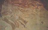
 | 24 May, 2003, NW of Edwards AFB: Speaking of neat planes, these dirty lumps of aluminum are all that remains of the YB-49, also known as the Flying Wing. It crashed during testing on June 5, 1948, killing a crew of 5 including Capt. Glen Edwards (for whom the base is named). Pete's grandfather was involved with its design and always had a strong opinion about the controversial project. The YB-49 was way ahead of its time, got squashed by political intrigue, but eventually was reborn as the B-2 Stealth Bomber. To see the YB-49 in action, watch the 1950s movie, "War of the Worlds". |
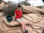
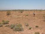 | 24 May, 2003, NW of Edwards AFB: Sarah stands on the edge of the impact crater. For more information on this very famous airplane, follow these links: http://www.xb-70.com/wmaa/yb49/ http://www.check-six.com/Crash_Sites/YB-49_crash_site.htm http://www.edwards.af.mil/gallery/html_pgs/bomber5.html http://www.edwards.af.mil/history/docs_html/aircraft/yb-49.html |
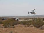 | 24 May, 2003, NW of Edwards AFB: The desert around Edwards is littered with dozens of famous airplane crash sites, but we were not too happy to find this wreck when we returned to the highway. A rolled over SUV required a medivac, and the helicopter landing in the middle of the road blocked all traffic, making it easy for us to get back on track. |
 | 24 May, 2003, Mojave National Preserve: Traffic on I-15 was bumper to bumper, thanks to all the people driving from LA to Vegas to throw their money away. Vehicles overheated and stalled every mile or so, waiting hours for the tow trucks. We exited the madness after Baker and headed south into the Mojave Preserve, and (with a hint from a country store owner) found an outstanding spot to camp. |
 | 24 May, 2003, Mojave National Preserve: Later in the evening we were unexpectedly joined by the Las Vegas Astronomy Society, holding a monthly star party. Despite setting up our own 10" Dobsonian reflector for excellent dark sky viewing, the LVAS club members snubbed us with barely a glance. The SF Astronomy Association and SF Sidewalk Astronomers are friendlier and more engaging by a country lightyear! Working alone for about 3 hours, Pete located M67 (open cluster), M44 (Beehive Cluster), M101 (Pinwheel Galaxy), M51 (Whirlpool Galaxy), M95 (spiral), M96 (spiral), M105 (elliptical), M65 (spiral), M66 (spiral, plus that mess of stuff in the Coma Berenices), M3 (globular), M53 (glob), M13 (Hercules Cluster), M92 (glob), M57 (Ring Nebula), M56 (glob), M4 (glob), M5 (glob), M107 (glob), M23 (open), M16 (open), M39 (another stupid open cluster!), NGC 6291, M102 (Spindle Galaxy), M40 (double star), M108 (spiral), M97 (Owl Nebula), M109 (spiral), M20 (Trifed Nebula), M21 (open cluster), M8 (Lagoon Nebula), M17 (Swan Nebula), M25 (open cluster), then got tired and went to bed. |
 | 25 May, 2003, Snow Canyon State Park, UT: We have stayed at Snow Canyon several times in the past (for good pics, see our trip last year), but this could be our last visit. The park is pretty enough, but the city of St. George has now sprawled right up to the gate and commuters use the park road as a shortcut. Loud families too closely packed in, pull-through RV sites, and high fees.... see ya later! |
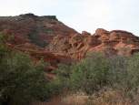
 | 26 May, 2003, Dixie National Forest (near Bryce, UT): Did we mention the weather had changed? Gotten hot? Really hot, hot, hot? We saw a very cool, wet spring, but now the temperatures were suddenly 90s-100s. After baking at Snow Canyon, we headed for higher elevations to cool off. At Zion it was 106 deg, so we bought our annual NPS pass and drove on through. On the way we checked out Alton, then the road to Cedar Breaks, but continued toward Bryce. Just north of Bryce we found a perfect site in the national forest, free and without other noisy campers. These are our own personal hoodoos a few hundred feet above our site. The bike tracks in the dirt were made during wet weather; their damage will remain visible for years. |
 | 26 May, 2003, Dixie National Forest (near Bryce, UT): From where we took the previous picture, this is the view looking down at our almost perfect campsite. We are at 7800' and it is in the high 90s. On our previous 2 trips here, we had 11" of snow and froze our water tank. This is not your typical late May weather. |
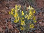 | 26 May, 2003, Dixie National Forest (near Bryce, UT): A benefit of the late spring rains... lots of beautiful wildflowers. |
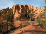
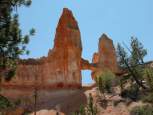 | 27 May, 2003, Bryce NP, UT: Hiking on the Tower Bridge Trail we found... the Tower Bridge. Did we mention it was hot? |
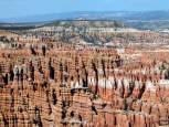 | 27 May, 2003, Bryce NP, UT: Hiking along the Rim Trail, the colorful hoodoos. Still very, very hot. A ranger I spoke with said that a week before they had blowing snow and had to evacuate unprepared campers. |
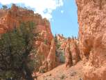 | 28 May, 2003, Bryce NP, UT: Hiking below the rim was even hotter. |
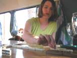 | 28 May, 2003, Bryce NP, UT: Our pastime, playing dominoes in the Puck while enjoying a glass of wine. Of course, Pete has double six (again). Sarah's monkey looks on and helps her cheat. |
 | 29 May, 2003, Grand Staircase-Escalante National Monument, UT: After 3 days in and around Bryce the hot weather showed no sign of change, but we had to move on. Decending to Tropic, Henrieville and Escalante, we were cooking again, so we pointed toward another high elevation, Boulder Mountain. At the town of Boulder we took a side trip on the Burr Trail down to Long Canyon. Deer Creek Campground looked nice, but at only 5700', too hot. Here is a slot canyon that was delightfully cool. |
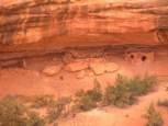
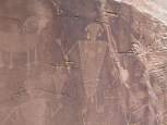
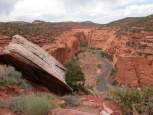 | 29 May, 2003, Grand Staircase-Escalante National Monument, UT: A view of the road in Long Canyon, beautiful and almost uninhabited. Anasazi petroglyphs abound. |
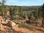
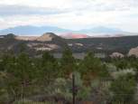 | 29 May 2003, Single Tree, Boulder Mountain, UT: Of the 3 National Forest campgrounds on Boulder Mt., only one is open (The Forest Service relies on volunteers to open them). The view from our campsite at Single Tree, overlooking the Waterpocket Fold (red ridge) of Capital Reef and the Henry Mountains in the background. Back up at 8000', we get a cool evening. |
 | 30 May 2003, Grand Staircase-Escalante National Monument, UT: Again we decend, to the Fruita campground in Capital Reef NP. Dropping off the Puck, we head down the Notom-Bullfrog Trail to check out a primative campground called Cedar Mesa, only about 5 miles from our location the previous day in Long Canyon. After 8 miles of teethjarring washboard road, it is clear we will not be dragging the delicate trailer to this campsite. I get a local paper and discover to my surprise that we are in a recordbreaking Heat Wave! At only 5600', the Fruita camp is cooking and buggy with mosquitoes. |
 | 31 May 2003, Capital Reef NP, UT: Before departing, we take a hike before 7am while it is still cool. Here is the reason why the ridge is called the Waterpocket Fold... the sandstone tilted on edge erodes to form numerous waterholes. For better pictures of Capital Reef, check out last year's trip (when it was much easier to hike around). |
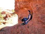
 | 31 May, 2003, Natural Bridges National Monument, UT: Leaving Capital Reef after just a day, we cross Lake Powell at Hite and head to Natural Bridges. Why? The campground is at 6500', that's why. Even at that height, there is little shade at the campsite and we cower under short trees. Sarah posed on our hike to Owachomo Bridge. |
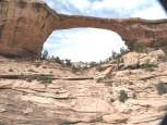 | 31 May, 2003, Natural Bridges National Monument, UT: Owachomo Bridge, 180' span. |
 | 31 May, 2003, Natural Bridges National Monument, UT: Horsecollar Ruin, c. 1300, seen from a distance. |
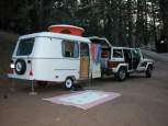
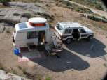
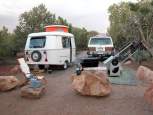 | 31 May, 2003, Natural Bridges National Monument, UT: Our little setup, jeep, Puck, telescope, etc. Pete got chewed up by dozens of black flies, that crawled under his hair and up his sleeves. Sarah doesn't seem to get a single bite. |
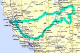
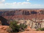 | 1 June, 2003, Canyonlands NP, UT: As seen on the map, to get about 50 miles north, we drove 160 miles in a circle. On the way we finally visited Moab, to see what all the hype was. Now we know, a backcountry hippie haven, chew bar and outfitting center, good for a fuel up and some fresh veggies. We quickly passed into Canyonlands and camped at Willow Flat. A plague of midges ruined an otherwise beautiful campsite, but we did get a good hike in at Upheaval Dome, seen here. |
 | 1 June, 2003, Canyonlands NP, UT: At the end of the trial at Upheaval Dome, Sarah avoids the hot sun, but the midges are soon on us. |
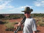 | 1 June, 2003, Canyonlands NP, UT: Pete here, making sure his dermatologist stays employed. |
 | 1 June, 2003, Canyonlands NP, UT: A pure art shot into the sun, which we liked because of the haze and overlapping distant hills and ridges. |
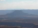
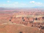 | 1 June, 2003, Canyonlands NP, UT: The view from Grand View Point. Who names these things? |
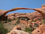 | 2 June, 2003, Arches NP, UT: Landscape Arch. Under the middle is debris from a recent rock fall. |
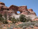 | 2 June, 2003, Arches NP, UT: Tunnel Arch. |
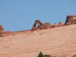 | 2 June, 2003, Arches NP, UT: Delicate Arch, seen through telephoto from about 1 mile. To the left are humans who hiked 8 miles in the heat. |
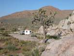
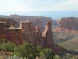 | 2 June, 2003, Colorado National Monument, CO: A new experience for us and the Puck, Colorado! About 6000' up, above yet another town named Fruita, just west of Grand Junction. |
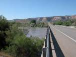 | 3 June, 2003, Fruita, CO: The late spring rains and snow have swollen the Colorado to within a few feet of flood stage. |
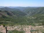 | 3 June 2003, Douglas Pass, CO: Route 139 in Colorado is an outstanding scenic byway, topped with Douglas Pass at 8240'. |
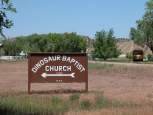 | 3 June 2003, Dinosaur, CO: This is not an observation on fossilized religious beliefs. |
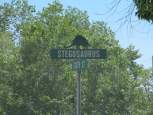 | 3 June 2003, Dinosaur, CO: This is a just a town that takes their prehistory seriously. |
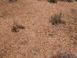
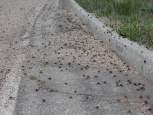 | 3 June 2003, Dinosaur National Monument, CO: As one should expect while visiting a prehistoric location, we encounter yet another plague of insects. Each about 1.5" long, we encountered mile-long patches of them. These are Mormon Crickets, millions of which covered the road to Harpers Corner. The locals all acted like nothing was amiss, yet 2 weeks later even CNN is reporting an unusually extreme infestation of these amazing creatures. Not pictured, and a tremendous oversight on my part, was the front of the Puck after driving through them. I spent the afternoon washing a very thick brown-red-green goo off the trailer. |
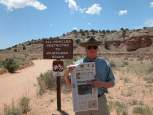
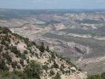 | 3 June 2003, Dinosaur National Monument, CO: Echo Park overlook. We wanted to camp down in Echo Park, but the many signs warning "Rough Road! No trailers!" kept us away. Next time, for sure. |
 | 4 June 2003, Dinosaur National Monument, UT: The monument spans two states, on the Utah side is the famous and fantastic dinosaur quarry. Ironically, Dinosaur NM would not need a single fossil to be a first-rate destination. The Canyon of Lodore, Split Mountain, the confluence of the Green and Yampa Rivers, the plague of crickets and rock art of the Fremont Culture provides more than enough to see. Riverboat tour groups were on the swollen rivers; we chatted with one tour operator. A 4 day excursion cost $750 per person, more than the cost of our 3 week trip! |
 | Pete took a dozen pictures of the huge Triassic fossils, hundreds of articulated bones still embedded in rock. Sadly, those images were erased accidentally, but you can find pictures easily on the Web. Sarah scanned this postcard to replace the lost images...Addendum: Pete found the missing images! |
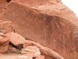
 | 4 June 2003, Dinosaur National Monument, UT: Petroglyphs on the road to Josie Bassett's cabin. |
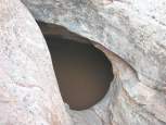
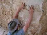 | 4 June 2003, Dinosaur National Monument, UT: In a box canyon behind Josie Bassett's cabin, rock climbing is easy when the erosion makes perfect fingerholes. |
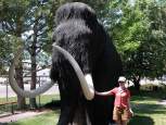
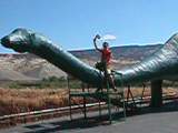 | 5 June 2003, near Dinosaur National Monument, UT: It's nice to have a live allosaurus to ride. |
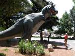 | 5 June 2003, Vernal, UT: This town is the gateway to the Dinosaur park, and is building a first class natural history museum. The old museum has a dinosaur garden that puts the past in perspective. |
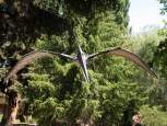 | 5 June 2003, Vernal, UT: At the Dinosaur Garden. |
 | 5 June 2003, Vernal, UT: Not a dinosaur, but hangs with them (and Sarah). |
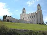 | 6 June 2003, Manti, UT: Utah roads 40, 191, 6 and 89 alongside and through the Uinta Mountains were eyepoppingly gorgeous with lots of vibrant green. We camped in the national forest lands behind Manti. Although a tiny town, it has a huge temple, which we almost got the courage to visit. Too many neatly dressed folks might have been upset with our rough look. |
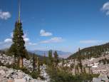
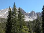 | 6 June 2003, Great Basin NP, NV: From Manti we zigzag through the range and basin, finally leaving Utah. Just over the border in Nevada is (besides the obligatory casino) a new park, Great Basin, dominated by 13,000' Mt. Wheeler. Seen this many times from crosscountry overflights, so it was nice to finally put our feet on it. We chose the highest camp at 10,000', mostly uninhabited and near the treeline. No problem keeping cool here, in fact, we noticed significant attrition each night from other campers who were not prepared for high altitude living. This is the view of Jeff Davis Peak from our site. Pete set up the scope and saw the best view of Mars this year at about 3am. No one else joined him, despite some interested parties who saw him setting up at dusk. |
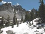 | 7 June 2003, Great Basin NP, NV: We hiked up through a large bristlecone pine forest, the trail frequently being covered by snow drifts. Trying to go around the drifts meant losing the trail, going through meant sinking up to your hips. Most hikers going for the summit this early in the summer can't get through the snow. |
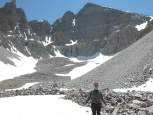 | 7 June 2003, Great Basin NP, NV: Sarah reaches Mt. Wheeler's tiny glacier, the only one in Nevada and the southernmost in the US. The summit is a mere 2,000' straight up. |
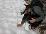 | 7 June 2003, Great Basin NP, NV: Verified proof, Sarah has touched her first glacier! |
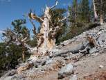 | 7 June 2003, Great Basin NP, NV: Among the many living 4,000-5,000 year old brislecone pines, this dramatic specimen is dead. |
 | 7 June 2003, Great Basin NP, NV: The bristlecone pine forest at the 11,000' treeline. The oldest trees live at the highest, most extreme environment, while wimpy young one millenium trees are lower. |
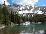 | 7 June 2003, Great Basin NP, NV: Lake Teresa, off on a side trail. |
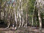 | 8 June 2003, Great Basin NP, NV: Are these trees drunk? Perhaps, but their strange gyrations are caused by geology and the frequent freeze-thaw cycling, which makes the soil creep downhill. |
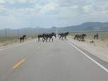 | 8 June 2003, Central Nevada, NV: Wild mustangs, hayburner type, not gasguzzlers, cross the highway ahead of a thunderstorm. |
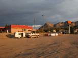 | 8 June 2003, Tonopah, NV: Our last night out, and our least appealing campsite. The casino offered free overnight RV parking and has bathrooms open all night... but since that offer also extended to truckers, we were serenaded to sleep with rumbling diesel engines and air brakes. Also police sirens all day and night, since Tonopah's 25 mph speed limit interrupts the 70 mph highway. If you don't slow down and gamble, they get your money anyway! |
 | 9 June 2003, near Lee Vining, CA: We took Rt. 120 to Lee Vining, crossed back into California just north of Boundary Mt., and faced our last range to cross, the Sierra Nevada. Tioga Pass into Yosemite had opened 3 days prior, so we had hopes of one last night of camping in the park. No luck, the NPS doesn't open the Tioga campgrounds until mid-July. No big deal, we head straight home and put the strange policies of the NPS and the Forest Service behind us. Our trip was 2,800 miles, 18 days, 10 national parks, 6 plagues, 1 long heat wave, and no flats this year! |